Spatial data and modelling
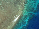
An aerial photo of waves breaking over a coral reef on the Great Barrier Reef. Advancing technologies are increasing our capacity to sample and model spatial variability in habitat distribution and environmental conditions.
Environmental issues are inherently spatial – the distribution of species, and human impacts on those species, vary across the land(sea)scape. Technological innovations, such as remote sensing and hydrodynamic modelling, over recent decades have vastly increased our capacity to study environmental drivers of marine systems at landscape scales. I collect and use spatial data sets to build models of coastal marine ecosystems. These models are then used to understand how human actions affect those systems.
See: Saunders et al. 2013, Saunders et al. 2014, Roelfsema et al. 2013, Roelfsema et al. 2014, Lyons et al. 2015